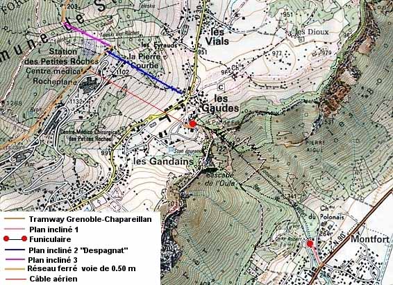
How
to build these big buildings on a such area without any access? The
solution was really ambitious. An incredible set of different cable
transportation systems was built to reach the area of the construction
from Grenoble and the Isère valley.
The main difficulty was to get over the 800 meters high cliff which
protect the Grande Chartreuse Massif. The solution was to build a
funicular but it was not sufficient. A small cable incline (called
Plan incliné 1 on the map below) was also built to link the
bottom station of the funicular to the tramway line Grenoble-Chapareillan
in the valley. Then another cable incline (plan incliné 2)
was built between Les Gaudes and the Petites Roches plateau. This
incline was called "Despagnat". On the plateau a real 50
cm gauge railway line was built to link the "Despagnat"
incline to the different sites of the three sanitariums. A third incline
(plan incliné 3) and a second 50 cm railway line were also
built to reach the quarry for the stones necessary for the construction.
After the opening of the funicular an aerial cable system (Câble
aérien on the map) which was used to build the funicular was
moved and reinstalled between Le Chalet (today Hotel Le Chalet) and
the sanitariums. Le Chalet was an additional building of the sanitariums
beside the top station of the funicular. This aerial cable was used
until 1981 to carry the meals of the Le Chalet residents from the
sanitariums and it was also used to carry up material from the funicular
to the sanitariums. But there is a gap between the top station of
the funicular and the bottom station of the aerial cable, another
small 50 cm gauge railway was built to link the two cable transportation
systems.
Today only the funicular is still in use. |
|
Comment
construire ces imposants bâtiments sur une telle zone sans moyens
d'accès? La solution fut réellement très ambitieuse.
Un incroyable réseau de différents sytèmes de
transport à câble et de voies ferrées fut construit
pour atteindre la zone de construction à partir de Grenoble
et de la vallée.
La principale difficulté fut de franchir la falaise de 800
mètres de haut qui protège le massif de la Grande Chartreuse.
La solution fut de construire un funiculaire mais ce n'était
pas suffisant. Un petit plan incliné à câble (Plan
incliné 1 sur la carte ci dessous) fut aussi construit pour
relier la gare basse du funiculaire à la ligne de tramway Grenaoble-Chapareillan
dans la vallée. Puis un autre plan incliné à
câble (plan incliné 2) fut construit entre Les Gaudes
et le plateau des Petites Roches. Ce plan incliné fut appelé
"Despagnat". Sur le plateau une voie ferrée à
écartement de 50 cm fut construite pour relier le plan incliné
Despagnat et les différents sites de construction des 3 sanatoriums.
Un troisième plan incliné à câble (plan
incliné 3) et une deuxième voie de 50 cm furent construits
pour atteindre la carrière où furent extraites les pierres
nécessaires aux bâtiments.
Après la mise en service du funiculaire un câble aérien,
qui avait servi à la construction du funiculaire, fut déplacé
et réinstallé entre Le Chalet (aujourd'hui l'hôtel
Le Chalet) et les sanatoriums. Le Chalet était une annexe des
sanatoriums situé à proximité de la gare supérieure
du funiculaire. Ce câble aérien fut utilisé jusqu'en
1981 pour acheminer les repas des pensionnaires du Chalet et élaborés
aux sanatoriums. Il fut aussi utilisé pour transporter les
marchandises depuis le funiculaire vers les sanatoriums. Mais il y
a quelques dizaines de mètres entre le Chalet et la gare du
funiculaire, pour franchir dcette distance une autre voie de 50 cm
pour relier ces deux sytèmes de transport à câble.
Aujourd'hui seul le funiculaire est encore en service. |